Maptrail
 Maptrail is a new variant on the maprun smartphone app. Maprun involves orienteering round a virtual course using the app and your map to visit as many checkpoints as you can. Route choice and navigation are key to a successful run.
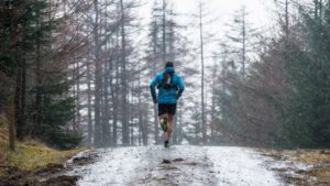
Maptrail is different. the course is fixed, and marked on your map, either a paper version or on your phone, but is not waymarked on the ground. You need to use the phone and app to navigate the course, but as well as the map, the phone shows you where you are, so you can keep track of your progress, and make sure you are still on the pre-defined course. Maptrail is a running activity, rather than a navigational one, not dissimilar to Strava, but with the ability to have split times throughout the course(segment), and a custom map, if appropriate. Maptrails can be set up anywhere. You are not confined to the forest; we have created a couple of maptrail fell runs, and would be happy to consider any ideas you may have for setting up something for your club or running group.
If you haven't used the maprun app before, have look at the Getting Started page to see how it all works.
You can find details of the maptrails on the Courses page.
Mapride
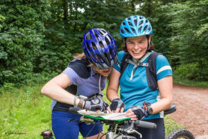 Mapride is simply maprun smartphone orienteering by bike. As well as our prototype course - Beechenhurst 90 - which is a 90 minute score course based on the Cycle Centre - Pedalabikeaway - in the Forest of Dean, we are pleased to announce Le Tour de Forêt, which is a multi-stage MTBO course covering most of the Forest of Dean.
Le Tour de Forêt
Le Tour will consist of 4 scatter stages, each using an A4 size 1:25,000 special map showing permissible cycle routes. Unlike Score events, where the objective is collect as many points as possible within a specified time, a scatter course requres you to visit every control, or a specified number, in any order, as fast as possible. Each stage has 2 options - the Grande, which requires you to visit all controls, or the Petite, where you need to visit any 15.
Each stage is set up as a Start Anywhere course, which means that you can start and finish at any control on the course, the finish one being the same one as the start. If on the Grande course you must also visit the designated start/finish, but you do not need to include it as one of your 15 on the Petite course. The stage details page shows suggested parking locations which have convenient start/finish controls nearby.
All courses have a generous 50m punch tolerance, and the options to show you current location and track are switched off but open for you to switch on if you wish.
You can find details of the mapride courses on the Courses page.
Beechenhurst 90
The objective is to collect as many points as you can in the 90 minutes allowed. if you are a quick rider you can probably clear the whole course in 90 minutes, but if you aren't that quick you need to think about which checkpoints you reckon you can get to in 90 minutes, and which have the highest scoring potential.
The app works exactly the same as for maprun running courses; it'll beep to signal you crossing the bridge over the road by the Cycle centre to start, and do the same as you finish. If you haven't used the maprun app before, check out how to download it and use it on the Getting Started page.
As with all maprun courses, this course is free and always available, to be ridden whenever you feel like it. To find the Cycle centre, see their website at https://pedalabikeaway.co.uk/
Like maprun courses, maprides can be score courses - visit as many checkpoints as you can in a given time - or line courses, where you work out the best route to visit a given set of checkpoints in the correct order in the shortest time. Our prototype course is forest based, but maprides can be set up anywhere - town or country. The only constraint is that in order to comply with Forestry Commission and typically other private landowner requirements, and contrary to what you might imagine given the amount of (unauthorised and probably illegal) off-track mountain biking throughout our area, forest courses are limited to the use of hard forest tracks only.