Newent
Unlike our other current courses, the standard Newent maprun course takes in some of the surrounding countryside as well as the whole of the town. You can run some of the local footpaths and country lanes between bursts of urban running. On top of this, there is a separate short course, called Newent Xplorer, which is confined to the area around the lake, involves no running across or along roads, and is ideal for youngsters having a try at maprun.
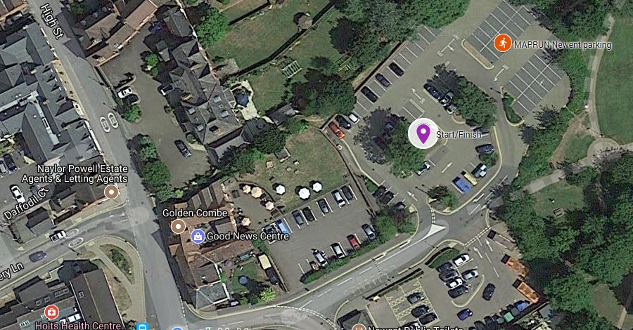
Parking for both courses is in the pay and display car park just outside the town centre. The turn towards the car park is directly opposite the Library and Holts Health Centre, on the High Street. Immediately after turning off the High Street the road bears round to the right. Go straight on and the car park is on your left beyond the Good News Centre parking. The parking charge is only 20p for 2 hours, and ceases after 6pm. There are public toilets across the road from the main car park, and there is a cafe in the Good News Centre. As the start and finish of the course are on the island in the middle of the nearer part of the car park, you should park either near the toilets, or further on into the main carpark, rather than right next to the Start/Finish.
Narest postcode: GL18 1AN
[bg_collapse view=”button-green” color=”#ffffff” icon=”arrow” expand_text=”Directions” collapse_text=” “]
Click on the running man on the map below, and then the![]() icon to get directions to the course.
icon to get directions to the course.
[/bg_collapse]
[bg_collapse view=”button-green” color=”#ffffff” icon=”arrow” expand_text=”Start and Finish” collapse_text=” ” ]
The Start and Finish are on the grassy island with a large tree on it just ahead of you as you turn into the car park. Make sure you run through this point to start your route, and again back through it to stop the clock on your run. Dont park too close to this spot as you risk inadvertently starting your course when to load it into the app and hit ‘Go to Start’ if you are actually standing by the Start, but not ready to go!
[/bg_collapse]
[bg_collapse view=”button-green” color=”#ffffff” icon=”arrow” expand_text=”Course Details and Map” collapse_text=” “]
View the course details and map below. These are all designed to be printed so you have the information to hand as you get on site, but the only thing you need to run the course is the map (and a phone!). We recommend you run with the course map and details sheet together back to back in a plastic wallet to keep them dry!
View or print the main course map
View or print the Xplorer map
View or print the location details
View or print main course checkpoint descriptions and getting started information
[/bg_collapse]