Hatherley
Hatherley maprun course starts and finishes next to the Morrisons store on Caernarvon Road on the outer edges of Up Hatherley. There is parking in the store car park, and also just beyond, in the library car park. The course takes in all of Hatherley, stretching up into the outskirts of Montpellier, and as far West as the edges of Benhall. It is generally flat, and there are no major roads to cross, though you must of course take care and be aware of traffic on all of the roads around the area.
[bg_collapse view=”button-green” color=”#ffffff” icon=”arrow” expand_text=”Directions” collapse_text=” “]
Click on the running man or the start/finish location on the map below, and then the![]() icon to get directions to the course.
icon to get directions to the course.
[/bg_collapse]
[bg_collapse view=”button-green” color=”#ffffff” icon=”arrow” expand_text=”Start and Finish” collapse_text=” ” ]
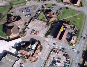
The Start and Finish are on the little pavement island with a green lamp post on it at the edge of the small section of the Morrisons car park behind the filling station. Make sure you run through this point to start your route, and again back through it to stop the clock on your run.
A different view, from the filling station approach….

[/bg_collapse]
[bg_collapse view=”button-green” color=”#ffffff” icon=”arrow” expand_text=”Course Details and Map” collapse_text=” “]
View the course details and map below. These are all designed to be printed so you have the information to hand as you get on site, but the only thing you need to run the course is the map (and a phone!). We recommend you run with the course map and details sheet together back to back in a plastic wallet to keep them dry!
View or print the course map
View or print the location details
View or print checkpoint descriptions and getting started information
[/bg_collapse]